Yukon
Call of the Wild
Published in the Fall 2010 Issue of Canadian World Traveller
Text and Photos by Michael Morcos
Alone in the Yukon wilderness, I pointed my trusty rental car down the Klondike Highway towards the purple mountains on the horizon.
The sun was setting behind the rugged peaks and I could hear a faint echo fading into the distance. Was it the howl of a wolf? The ghost of a gold miner? A trapper calling his husky? Then I realized: it was the call of the wild.
The Majestic Yukon
The westernmost of Canada’s three northern territories, the Yukon lies directly above British Columbia and borders the US state of Alaska all the way up to the Arctic Ocean.
The Yukon’s 482,000 sq. kilometre territory (the size of a large chunk of Europe) has a population of only 34,000 people because of its forbidding terrain, isolation and harsh winter climate.
Beautiful Summers
 In summer, though, it’s a very different story: Visit during the sunny months of July and August, when daytime temperatures hover around 25° C, and you’ll find an unspoiled natural paradise filled with snowcapped mountains, majestic woodlands and rolling tundra.
Wildlife abounds – bears, wolves, lynx and caribou. The excellent local highways make for easy driving, while the park system, which includes Kluane National Park, a UNESCO World Heritage Site, offers a wealth of recreational opportunities.
River rafting, boating, fishing, hiking, climbing, horse riding, bicycling, and nature tours top a long list of outdoor activities. Campgrounds all seem to come with spectacular views and walks.
Naturally, the farther north you venture, the more polar your surroundings become. Around the Inuit town of Inuvik, located on the Arctic Ocean at the end of the Dempster Highway, polar bears, ice floes and muskox are part of the local scenery.
 History and Culture
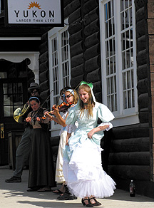
Remote as it is, the Yukon boasts a rich history and vibrant culture. First Nations and Inuit peoples have lived in this demanding environment for millennia.
The Yukon was the site of the 1898 Klondike Gold Rush, immortalized in print by Jack London (Call of the Wild), and commemorated today in places like Dawson City, where celebrating a frontier heritage is an everyday activity.
The Yukon’s rugged can-do spirit is still evident today. Prospectors, fur trappers, dog sledding champions and backwoods characters will feature prominently in any visitor’s trip, all of them happily showing off the local sights.
City of Whitehorse
 I began my own exploring in the Yukon’s capital of Whitehorse, less than two hours by air from Vancouver, BC or Edmonton, Alberta. A pleasant, hilly city of 23,000 (three-quarters of the Yukon’s population), Whitehorse lies on the Yukon River at kilometre 1425 of the fabled Alaska Highway.
Modern, comfortable, yet filled with reminders of pioneer life, the city has many galleries, restaurants and boutiques offering special northern fare.
Local attractions include the SS Klondike, a gold-rush paddleboat (banks of the Yukon River downtown); the Yukon Visitor Centre (100 Hanson St), featuring a two-storey relief map of the territory; and the Beringia Interpretive Centre (km 1422, Alaska Hwy), with exhibits of wooly mammoths, sabretooth cats, and other relics of the Ice Age.
Just outside Whitehorse is Miles Canyon, which offers a suspension bridge and river rafting (km 1416, Alaska Hwy). I stayed in Marsh Lake, a neighbourhood on the city’s edge with many hotels and B&Bs; the area is known for wetlands and birdlife.
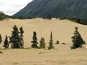 World’s Smallest Desert
My next excursion was a 30-minute drive to the Southern Lakes region, filled with excellent fishing (trout, salmon) and crystalline, azure bodies of water.
Close to the BC border, I stopped at the “world’s smallest desert,” a 260-hectare area known as the Carcross Desert that is actually a series of sand dunes deposited by extinct glaciers.
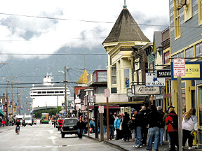
The 178-km long White Pass and Yukon Route, a popular narrow-gauge heritage railway, passes by here as it heads to Whitehorse from the Alaska Panhandle town of Skagway, a popular berth for cruise-ship lines.
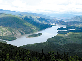
 Dawson City
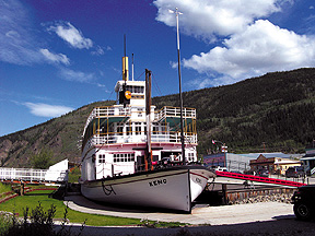
During the 1898 gold rush, thousands of people struck by “gold fever” landed in Skagway to get to the Klondike gold fields in the Yukon interior. Dawson City, 536 kilometres northwest of Whitehorse, became the largest city above Seattle.
Now a quaint hamlet of 1,827, Dawson City has historic buildings, restored paddleboats, and costumed re-enactors (try Parks Canada’s walking tours). Hikes in the original goldfields are permitted.
Downtown, the Dänojà Zho Cultural Centre, “Long Time Ago House,” celebrates and shares the culture of the local First Nations. Open for visiting, the nearby Robert Service Cabin was once the home of the poet who wrote works like The Cremation of Sam McGee.
Outside town is the Dome, a high, rounded peak (drive or hike) that offers panoramic views best seen late at night. This is the land of the Midnight Sun, after all, which is why playing midnight golf at the Top of the World Golf Course is a great alternative to sleep. Take the ferry across the Yukon River to get there: it’s close (8 km) and well signposted.
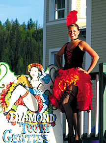
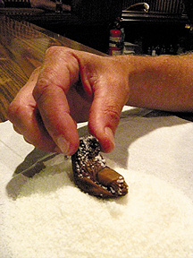 Sourtoe Cocktail
Every visitor to Dawson City remembers Diamond Tooth Gerties and the Sourtoe Cocktail. Gerties is a full casino, bar and eatery done up in 19th century saloon style.
Gamblers whoop it up like gold-rush prospectors while Gertie and the can-can girls put on three shows a night.
At the Downtown Hotel’s Sourdough Saloon, the main attraction is a cocktail containing a mummified human toe – the kind of tradition that could only start in a mining camp.
Drain the cocktail, touch the severed appendage with your lips, and you become one of the 65,000 worldwide members of the illustrious Sourtoe Cocktail Club. Just ask for the “toe,” and hope it hasn’t been swallowed again.
 Top of the World Highway
Heading west out of Dawson City, I took the spectacular Top of the World Highway, winding through pristine alpine backcountry into Alaska.
Because of its high elevation, the road is open only in summer; after twisting past endlessly impressive mountain ranges, I arrived safely in the wonderfully named Chicken, Alaska (pop. 11).
From here, I drove south through steep valleys and glaciers until I veered back across the border into the Yukon, ultimately reaching Canada’s westernmost community, the village of Beaver Creek.
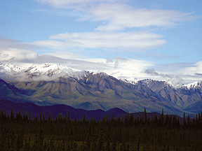
Kluane National Park
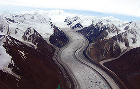 From Beaver Creek, it’s a morning’s drive east on the Alaska Highway to reach Haines Junction, a picture-postcard hamlet on the edge of Kluane National Park, one of the world’s top wilderness adventure playgrounds.
Home to Mt. Logan, Canada’s highest peak at 5,959 metres, the mountainous Kluane area contains enormous glacial icefields and famous white-water rivers like the Alsek and Tatshenshini.
Animal watching (grizzlies) in its open valleys, lush forest and alpine lakeland is de rigeur: look for cliff-side herds of rare Dall’s sheep.
Outdoor activities range from the standard (canoeing and camping) to the superlative – anything from heli-hiking to glacier flight-seeing can be arranged.
Kluane’s status as a UNESCO World Heritage Site is well justified, given its transcendent beauty, but its natural settings also offer endless opportunities for adventure sports, whether kayaking, fly-fishing, or rock climbing.
 Call of the Wild
Once I left Haines Junction, the 158 kilometres back to Whitehorse passed in a flash. Waiting to fly out at the airport, I reflected on my travels alone through the majestic Yukon wilderness.
Then, as I regretfully boarded my plane, I heard again that faint echo in the distance – undoubtedly, the call of the wild.
For More Info on Yukon:
Visit Tourism Yukon:
Official Website: www.travelyukon.com